
- Topics
- Feature
- Opportunities & Events
- About
- Hindi Portal
- Data
- Topics
- Feature
- Opportunities & Events
- About
- Hindi Portal
- Data
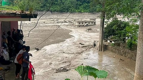
The flood swept away homes, roads and bridges in Nepal's Rasuwa district, along the Bhote Koshi River/ (Image: AFP, Wikimedia Commons)

The Himalayas have just delivered a devastating reminder of what happens when a rapidly changing cryosphere collides with vulnerable mountain communities. On 26 August, a glacial collapse in Nepal’s Langtang region triggered a massive debris flow and flash flood that travelled nearly 100 kilometres downstream along the Trishuli and Bhote Koshi river systems, destroying homes and critical infrastructure and killing hundreds of people. The disaster also created a new barrier lake, raising fears of another flood even as rescue operations were under way. The event may not fit neatly into the conventional definition of a glacial lake outburst flood, but that distinction is increasingly beside the point: it demonstrates how glacier collapse, landslides, temporary river blockages and sudden water releases can combine into cascading hazards across the Himalayas.
It is precisely this emerging risk landscape that gives new urgency to the paper “Time to diffuse the ‘ticking time bombs’ of the Himalaya” by Anshuman Bhardwaj, Sheikh Nawaz Ali, Lydia Sam and Pratima Pandey. The authors argue that while scientists have become increasingly proficient at mapping and modelling glacial lakes, far less attention has gone into the harder question of how these hazards can actually be prevented or mitigated.
The Himalayan cryosphere is melting faster than management institutions can adapt. Expanding glacial lakes, often retained by unstable natural dams, pose a growing risk of devastating Glacial Lake Outburst Floods (GLOFs). These events carry ice and debris downstream, threatening communities, infrastructure, and ecosystems.
The threat extends beyond glacier loss to the dangerous spatial reorganization of mountain hazards near growing populations and hydropower projects. A 2003–2023 bibliometric study reveals a critical research imbalance: while science excels at mapping lakes and tracking hazards, practical mitigation solutions—such as engineering, siphoning, and community participation—remain severely under-researched.
Policymakers must shift focus. The world cannot spend another decade perfecting the documentation of a disaster it fails to actively prevent.
The Himalayan cryosphere is melting faster than management institutions can adapt. Expanding glacial lakes, often retained by unstable natural dams, pose a growing risk of devastating Glacial Lake Outburst Floods (GLOFs). These events carry ice and debris downstream, threatening communities, infrastructure, and ecosystems.
The threat extends beyond glacier loss to the dangerous spatial reorganization of mountain hazards near growing populations and hydropower projects. A 2003–2023 bibliometric study reveals a critical research imbalance: while science excels at mapping lakes and tracking hazards, practical mitigation solutions—such as engineering, siphoning, and community participation—remain severely under-researched.
Policymakers must shift focus. The world cannot spend another decade perfecting the documentation of a disaster it fails to actively prevent.
Scientific understanding of Himalayan glacial lakes has advanced significantly through satellite remote sensing, digital elevation models, and bathymetry, enabling precise tracking of lake expansion. However, risk assessment is not risk reduction.
GLOF risks are rapidly multiplying due to interacting climatic, geomorphic, and human factors. Glacier recession expands lake volumes, while surrounding unstable slopes raise the threat of displaceable landslides. Simultaneously, extreme weather causes sudden volume spikes, while downstream deforestation, expanding settlements, and infrastructure increase human exposure. Treating lakes as isolated objects on satellite maps is insufficient; assessment must shift from a lake-centric approach to a holistic catchment-to-downstream risk framework.
Furthermore, relying solely on early warning systems is an incomplete strategy. Early warnings act only as a last line of defence by offering brief evacuation windows without eliminating the physical hazard itself. True safety along mountain rivers requires combining downstream emergency preparedness with direct hazard engineering.
Made using Gemini AI
Made using Gemini AI
The most urgent priority is developing a mitigation portfolio for high-risk Himalayan lakes through controlled lake-level lowering, siphoning, drainage, outlet modification, and dam reinforcement. However, these are not universal solutions—their feasibility depends on local morphology, accessibility, dam composition, and downstream conditions.
Despite existing for decades, techniques like siphoning remain marginal in policy due to institutional failures rather than technological limits. Financial, administrative, and scientific systems have failed to scale these solutions. To address this, Himalayan countries like India should establish a risk-based mitigation pipeline. This involves ranking high-risk lakes using standardized criteria—combining hazard probability, flood magnitude, downstream exposure, and intervention feasibility—and commissioning engineering studies for top-priority sites to allocate resources effectively.
Critically, physical interventions must not become technocratic silos. Because engineered changes affect water availability, ecosystems, and local livelihoods, downstream communities must help shape mitigation design rather than being treated merely as evacuation recipients.
The proposed SWOT framework provides a practical tool for this integration by forcing policymakers to evaluate four key questions simultaneously:
Strengths: What technical solutions can be implemented?
Weaknesses: What internal institutional or structural barriers prevent execution?
Opportunities: What external factors can make interventions long-term and sustainable?
Threats: What environmental, socio-cultural, or economic risks could undermine success?
The social dimension of GLOF risk remains critically under-researched compared to remote sensing and modeling. A warning system fails if communities lack trust, clear directions, safe zones, or evacuation training.
Effective management requires incorporating downstream populations into mitigation planning and systematically leveraging local knowledge. Remote mountain residents offer crucial insights into historical floods, shifting streams, and environmental signals that satellite data miss. Governments should establish actionable community-based preparedness plans—defining evacuation routes, safe zones, communication protocols, and volunteer networks—while using verified citizen science to supplement technical data.
Translating science into policy requires addressing institutional fragmentation. GLOF risks cross administrative and national boundaries, yet management bodies operate in isolation. The paper advocates for interdisciplinary integration and an intergovernmental research platform, similar to ICIMOD, dedicated to glacial-lake risks. For India, the primary focus must be integrating cross-border scientific coordination directly into existing disaster management, meteorological, and infrastructure systems rather than creating isolated platforms.
Mitigation does not end with construction; it requires continuous performance tracking across risk models, structural durability, monitoring accuracy, and community response as conditions change. India should implement a standard GLOF mitigation performance framework to assess physical hazard reduction, downstream exposure reduction, warning-system reliability, community preparedness, and institutional response. This approach should integrate Multi-Criteria Decision Analysis (MCDA) to evaluate technical, social, economic, and ecological trade-offs transparently, while incorporating ecosystem-based adaptations like slope stabilization and wetland restoration alongside structural measures.
The ultimate objective is not engineering every lake, but creating a layered system where scientific monitoring, targeted engineering, ecosystem restoration, and local preparedness reinforce one another. Following the UN's 2025 International Year of Glaciers' Preservation, policymakers must shift from merely mapping hazards to executing targeted risk reduction. The "ticking time bombs" of the Himalayas persist not because the science is unknown, but because implementation lags behind knowledge.
Ultimately, mitigation must become an adaptive, iterative process rather than a static project—converting data into real-time learning, evaluating every warning, and continuously adjusting measures against evolving climatic conditions. The region does not just need to predict where the next GLOF will happen; it needs actionable, pre-emptive solutions before disaster strikes.